
Inondations à Dakar : quand la ville souffre d’une spatialisation sauvage du social combinée à une socialisation sauvage de l'espace
For over two decades, the Dakar region has suffered from recurring cyclical flooding, with damages estimated at tens of billions of CFA francs (35.5 billion CFA francs for the 2009 event alone) and public health problems (proliferation of waterborne diseases such as cholera and malaria caused by stagnant rainwater). Despite the political response, structured around the activation of the ORSEC plans (2005, 2009, 2012, 2019, 2020, 2021, and 2022), the problem of flooding, with its devastating consequences, persists and remains just as severe. This raises the debate on the relevance and effectiveness of the measures proposed so far by public authorities. In the search for solutions, an analysis of flooding, integrating social and spatial parameters, becomes a relevant scientific approach. The floods in Dakar are not simply a hydro-climatic inevitability, but rather the product of a dysfunctional urban system, which can be summed up as a wild spatialization of the social (spontaneous, unequal and unplanned projection of social relations with space) combined with a wild socialization of space (result of a brutal and unregulated anthropization of the environment: impermeability, obstruction of outlets, waste and wastewater in the networks, etc.).
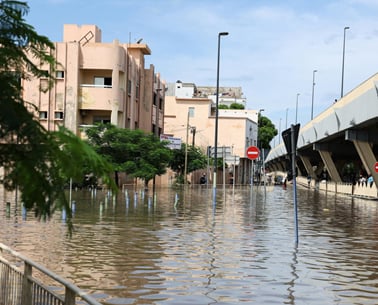
The settlement of low-lying areas is not a matter of topography, but rather a social selection driven by intense land speculation (informal land market and lack of affordable housing). The population shifts from Dakar to the Dagoudane and Pikine areas were already described by Vernière as early as 1973. The " return to normal wetlands" revealed the consequences of the initial urban sprawl of the suburbs into the now-drained Niayes region . Other sources, such as the World Bank's Post-Disaster Assessment (2010), maintain that " between 1988 and 2008, 40% of new settlements in Dakar occurred in wetlands ." This has resulted in an accumulation of precarious housing, with mobility deficits and high exposure to flood risk (Cissé, 2022). Furthermore, the Jaxaay Plan, by accelerating peri-urbanization through the relocation of 3,000 households to Keur Massar, in neighborhoods themselves prone to flooding, has paradoxically increased the vulnerability of those relocated. Finally, detailed mapping of the overlap between poverty (housing index) and price per square meter according to residential areas (land speculation and hydrological susceptibility) will statistically demonstrate the spatial distribution of the most vulnerable populations to the lowest-lying, most threatened areas.
A symmetrical process is triggered by the perverse forms of occupation and exploitation of the environment, to the point of disrupting its natural functioning. On the sandy soils of the region, natural runoff was negligible. However, it is now observed that the volume of runoff increases proportionally to the rate of urbanization, because soil sealing due to construction and roads reduces infiltration and increases runoff. For example, " urbanization has intensified sharply in the Keur Massar department, increasing from 10% to 60% between 1983 and 2020 " (Sagna, Descroix and Sow, 2024). This massive soil sealing has, in turn, caused a sixfold increase in runoff volumes. Added to this is the disruption of the natural drainage system of the Grande Niaye basin in Pikine, where natural ponds have been filled in, drainage channels fragmented, and the floodplain occupied by human settlements. Hence the need to use high-resolution topological drainage modeling to reconstruct microtopographies and residual flows that have become invisible on the ground (Diémé et al., 2022). The uncontrolled socialization of space is manifested on the ground through heterogeneous individual embankments (which displace water onto neighboring properties), deposits of solid waste, and domestic wastewater that clog drainage canals and basins. Thus, the risk of flooding in Dakar is a co-production: it results from both rainfall and urban development. For a better understanding of the phenomenon, future studies should focus on quantifying the relationship between the runoff coefficient and the soil impermeabilization rate by catchment area, on the one hand, and on carrying out a geolocated inventory of obstructions (embankments, constructions, deposits) that hinder drainage, on the other hand.
It has been established, through ethnography of working-class neighborhoods, that public action was long reactive and curative (pumping, temporary housing in schools, etc.) before becoming more strategic (Jaxaay Plan, PROGEP 1 and 2), without continuity of maintenance or urban planning enforcement. This explains the disregard for or non-application of urban planning tools, resulting in the development of housing estates in non-building zones, the construction of roads without consideration for the natural drainage system, and the expansion or urban sprawl from Dakar towards Thiès and Mbour without prior integration of green and blue infrastructure. An analysis of the institutional framework, along with the dynamics of stakeholder interactions (State, ADM, municipalities, donors) and the overlapping responsibilities following Act III of decentralization, constitutes a key step in finding solutions. Identifying the roles and responsibilities of stakeholders remains a relevant criterion for assessing the actual enforceability of flood zones: normative scope, application in building permits and actual capacity to prevent urbanization of at-risk areas.
The role of hydro-climatic events in flooding is not denied. On the contrary, it is put into perspective. Dakar is bearing the brunt of the intensification of extreme rainfall combined with the rising water table of the Quaternary sands and the inability to drain runoff by gravity towards the sea or into the lowest-lying basins. Measurements combining rainfall and runoff, taken in the 1990s and subsequently extended by recent hydrological simulations (EGUsphere, 2024), show that, for the same amount of precipitation, current floods are far more severe than those of the 1980s. For example, a rainfall total like that of August 2009 (283.7 mm in one month, causing the deaths of 6 people in Dakar and 13 nationwide) now generates significantly larger volumes of runoff, submerging neighborhoods for considerably longer periods. During the historic rainfall event of October 3-4, 2026, the Keur Massar weather station recorded an exceptional 111 mm of rain in less than 24 hours. This plunged the department and certain localities such as Pikine, Thiaroye, Guinaw Rail, and Diamaguène-Sicap Mbao into flooding for several days. Thus, climate change alone does not explain the disaster; rather, it amplifies a risk largely caused by human activity.
The persistence of stagnant water (3 to 6 months) after the rainy season poses significant social and health risks: drowning, a cholera epidemic in 2005 (Faye et al., 2013), a resurgence of malaria, skin diseases, well contamination, school closures, loss of assets, school dropout rates, and impoverishment. The assessment of the damage incurred does not allow for an estimation of the indirect costs to health and mobility, which are borne primarily by women, children, and the informal businesses identified in Pikine, Guédiawaye, and Keur Massar. For better prioritization of interventions, it would be relevant to establish a composite index of social and health vulnerability that simultaneously considers the duration of stagnation, access to healthcare, the level of sanitation services, and household income.
For each problematic area presented above, a solution of the same nature must be proposed. The aim is to distinguish between curative measures (protecting affected households) and preventive measures (risk avoidance) in order to move towards transformative measures (changing the urban model). These solutions will seek to build upon existing public policies by addressing their inherent contradictions (PROGEP and the Jaxaay Plan), according to the principle of governance that shifts from "fighting against" to "living with."
This principle allows flood zoning to be made legally enforceable and compensated, with a right of pre-emption, a land reserve for drainage, and an offer of affordable, risk-free housing. The aim is not to prohibit habitation, but to prohibit exposure without compensation. As long as the flood zone is not legally binding on third parties (annexed to the urban planning document, included in the planning certificate and building permit), the prohibition remains merely an intention. As long as there is no risk-free land supply and no fair compensation, the prohibition is socially unenforceable and legally precarious. The three-pronged approach is therefore: (i) to define the risk (hazard, stagnation, groundwater), (ii) to make it legally enforceable, and (iii) to provide compensation (pre-emption, land reserve, relocation). The precautionary principle is governed by Law No. 2023-15, the Environmental Code, which specifies that " any development/subdivision project in or near a wetland or flood zone is subject to an environmental and social impact assessment ," including a public inquiry. The precautionary and preventative principles justify refusing to authorize a subdivision in a high-risk area, even in the absence of absolute certainty.
This principle guides the integration of green and blue corridors (protected Niayes wetlands, ponds, channels, and basins) into land-use planning policies. This will be achieved through a strict ban on landfill in the floodplain and contractual maintenance of existing structures. Indeed, water deprived of its natural space encroaches upon the space occupied by human settlements and infrastructure.
In the Dakar region, each filled-in pond in Malika or Mbao, each narrowed channel in Pikine, diverts between 10,000 and 30,000 m³ of runoff downstream. Therefore, creating a protected area means classifying the basin and its bed and prohibiting further filling, while maintaining it means contracting with a certified technical operator for annual emergency dredging. The protection of sensitive ecosystems (coastline, wetlands, Niayes) relies on prohibiting any disruption to their balance. Any filling, drainage, or draining of a pond exceeding permitted limits must be submitted to the relevant authority for authorization. The Forestry Code (Law 2018-25) and Decree 2019-110 enshrine the protection of the Niayes by specifying that " the Niayes (dunes, wet depressions, lakes, forests) fall under the classified forest domain, the reforestation and restoration perimeters (Niayes Perimeter – areas of Malika, Mbao, Pikine). For this purpose, clearing, filling and construction are prohibited there without express declassification by decree ".
Decrees No. 2018-1738 and 2018-1740, which partially reclassified Malika for housing development purposes, clearly demonstrate the risk that must be avoided. From now on, no reclassification will be permitted except in exceptional circumstances, and subject to the cumulative fulfillment of three conditions: (i) it must be duly justified by a demonstrated public interest, (ii) it must be subject to equivalent ecological compensation, and (iii) it must be subject to a prior Environmental and Social Impact Assessment (ESIA). Furthermore, from a doctrinal standpoint, it is proposed to establish a moratorium on any new reclassification affecting the metropolitan blue network. This encompasses all watercourses, wetlands, and hydrological corridors within the metropolitan area.
Every newly built square meter must incorporate water infiltration and storage techniques (biochar, swales, permeable paving, reservoir pavements). Dakar has gone from an infiltrating sandy soil (Niayes, dunes) to an urban "sheet metal " landscape. Runoff is five times greater, and retention basins become saturated in about 30 minutes. Therefore, applying the " zero additional discharge " doctrine is the only way to reverse the load. It will thus be up to the applicant to prove that they are not worsening downstream conditions. Low-maintenance construction techniques adapted to the sand and the shallow water table must be promoted to restore infiltration. And, direct infiltration is prohibited where the water table is extracted for drinking water without pretreatment. Major projects (ZAC, roads, industrial zones, stadiums) must demonstrate their hydraulic neutrality through a hydrological study specifying the flows (leakage flow ≤ natural flow) and the measures (avoidance, reduction and compensation) before any development.
The system's governance rests on four essential pillars: (i) the Metropolitan Water and Risk Authority , which manages, coordinates, and arbitrates; (ii) the Urban Planning Police , which monitors building compliance and penalizes violations; (iii) a protected and non-reallocation maintenance budget to guarantee the long-term upkeep of infrastructure; and (iv) a land-use imperviousness fee , paid by landowners who develop their land to finance the system and encourage compliance with regulations. The Sanitation Code provides for sanitation fees (wastewater and stormwater) based on water consumption and/or the impervious surface area. Following this same logic, a metropolitan land-use imperviousness fee— expressed in X FCFA/m² of impervious surface/year, with exemptions for proven infiltration —must be legally established to serve as an environmental service tax, allocated to a Metropolitan Maintenance Fund (dredging, pumping, spare parts).
A metropolitan observatory must be created to monitor climate information, groundwater levels, and flow rates through early warning tools (SMS, community radio, risk awareness programs in schools). There can be no governance without measurement, no safeguarding without prevention, and no resilience without memory. Effective management requires measurement as a prerequisite for knowledge and decision-making; protection requires prevention as a prerequisite for anticipating risks; and resilience requires memory and lessons learned to avoid the recurrence of past crises: " what is forgotten is destined to happen again ." The Dakar region has scattered data (ANACIM on rainfall, DGPRE on groundwater, ONAS on flow rates), but no coordinating unit (observatory) to merge them into a synergy of actions. Memory (flood markers, totems, schoolyards) must be used to avoid repeating past mistakes (rebuilding identically after each rainy season).
Through a dual conceptualization tested empirically (uncontrolled spatialization/socialization) and a systemic model with quantification of the urbanization effect, it appears that the cyclical floods in the Dakar region are neither a climatic curse nor a sign of popular incivility, but rather the clear symptom of a sprawling spatial production system. The "uncontrolled spatialization of the social" has crowded vulnerable households into low-lying areas prone to flooding, while the "uncontrolled socialization of space" has progressively obstructed and rendered impermeable the low-lying areas. It is therefore necessary to move from crisis management (pumping, sheltering in schools, hastily relocating) to a more coherent, inclusive, and operational governance of the system. Thus, Dakar's " water city " constraint could evolve and be transformed into a strategic resource through the protection of the Niayes wetlands, the delimitation of floodplains, the development of drainage-friendly neighborhoods, and the promotion of hydrological citizenship. The contribution of geography (the science of the spatial organization of societies) to the analysis and management of flood risk in Dakar stems from a territorial diagnosis aimed at guiding the action of public authorities: " understanding in order to act ".
Dr. Mamadou Fall, Geographer-Environmentalist
Environment Specialist at the Directorate of Infrastructure and Development (DIA) of the National Program for Community Agricultural Domains (PRODAC)


















Commentaires (5)
Contracter une societe chinoise ou Russe pour un assainissement et des irrigations completes du pays et je jure le probleme est regle.
Participer à la Discussion
Règles de la communauté
💡 Astuce : Utilisez des emojis depuis votre téléphone ou le module emoji ci-dessous. Cliquez sur GIF pour ajouter un GIF animé. Collez un lien X/Twitter, TikTok ou Instagram pour l'afficher automatiquement.
Se connecter
Commentez avec votre profil, votre photo, et soyez averti des réponses.