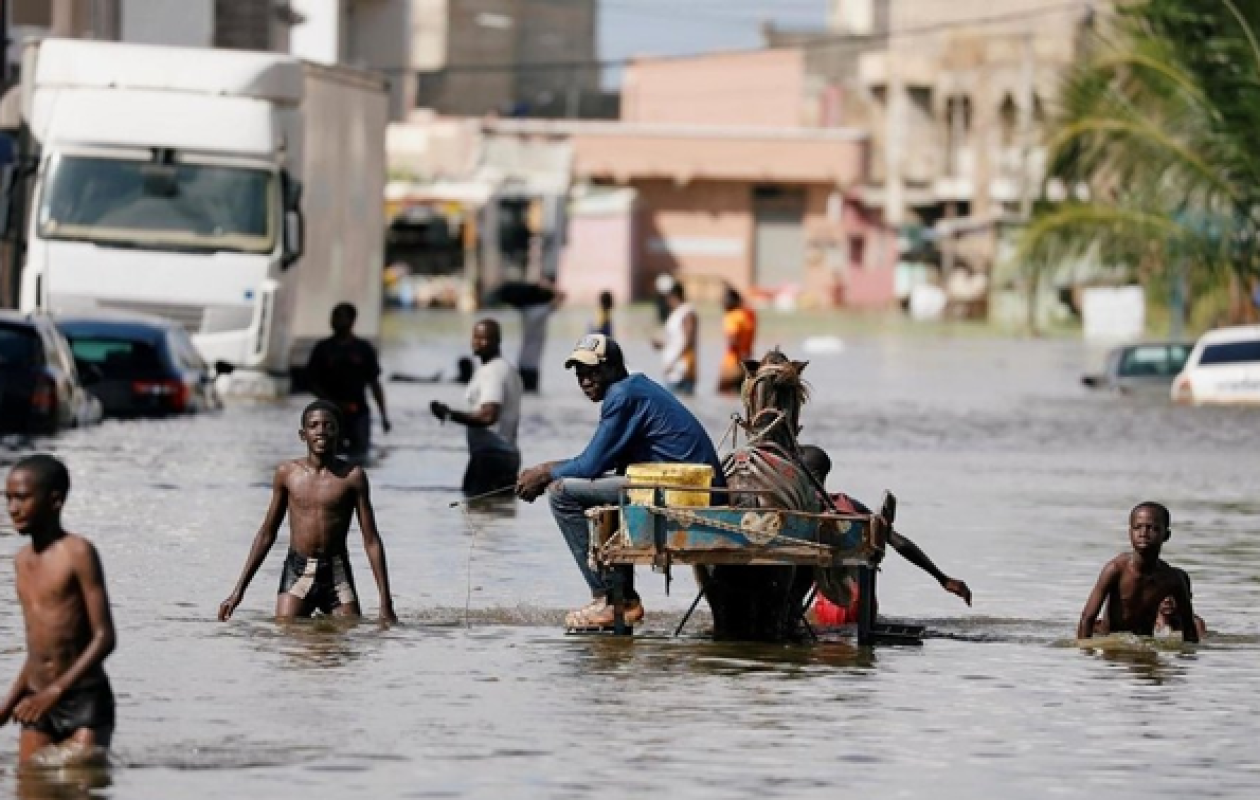
INONDATIONS A DAKAR ET ENVIRONS LES MEMES CAUSES PRODUISENT TOUJOURS LES MEMES EFFETS (Kadialy Gassama)
At the end of the rainy season, heavy rains struck Dakar this weekend, causing widespread flooding in the capital. In just a few hours, entire sections of neighborhoods and roads were completely submerged, resulting in significant material damage, loss of life, and paralyzing traffic. The Cap-Vert peninsula was suddenly plunged into a scene of utter devastation, just a stone's throw from the start date of the Youth Olympic Games on October 31st.
The infamous problem of recurring flooding in Dakar and its surrounding areas is inextricably linked to the massive influx of people to a small peninsula, resulting in poor land management and exacerbated by the particularly aggressive coastal erosion that is devouring entire sections of the shoreline. Indeed, the Cap-Vert peninsula has experienced, over the past fifty years since 1970, a massive displacement and settlement of populations from all corners of the country's interior and neighboring states, due to established and strengthened economic ties there. With normal to above-average rainfall, the Cap-Vert peninsula did not suffer from flooding, specifically during the period when the natural Thiaroye pond existed, its bed covering the entire area of Thiaroye up to the outskirts of Mbao; the marshland of the well zone (Patte d'Oie, Maristes, Foire, Grand-Yoff, Dalifort up to the ocean); the mangrove of the Dakar technopole perimeter, which covered a large part of Pikine; and the Ndéfane stream of Rufisque Ouest, which extended as far as Keur Massar and Jaakhaye. It has taken the development of social housing in the last fifty years, with the natural rainwater catchment areas, for a few millimeters of water to flood Dakar and its surroundings. Even in the dry season, in many places on the Cape Verde peninsula (Pikine, Thiaroye, Yeumbeul, Patte d'Oie, Mbao, Maristes, Foire, Grand-Yoff, Dalifort), stagnant water and humidity permanently adorn the scenery of populous neighborhoods, due to the shallow water tables.
In essence, this means that economic reasons were at the root of the massive population displacements as people fled the severe drought of the 1970s and 80s, moving from the interior of the country to a peninsula whose landmass is shrinking further due to coastal erosion. This peninsula's topography and ecosystem are naturally intertwined with mangroves, which serve as aquatic environments for rainwater harvesting. These same populations abandoned the lands of Cayor, Baol, Ndiambour, and parts of Sine and Saloum. The drought of the 1970s, which lasted for more than a decade, triggered a major rural exodus, hindering the development of the agricultural and industrial potential of the interior regions. This large-scale migration has led to the formation of a hypertrophied informal economy in the Dakar region, based primarily on the trade of imported or recycled goods and low-level jobs that do not generate added value. This critical mass of workers constitutes an army of street vendors and traders occupying public spaces. The informal commercial sector is becoming a major obstacle to balanced development and the quality of urban life.
Not only does the proliferation of small markets throughout the capital's streets impede traffic, but this situation also contributes to making the capital more unsanitary than it was before, due to the unbearable human congestion. On one side, there are the mechanics who invade certain streets of the capital to carry out their garage work on abandoned vehicles; on the other, the street vendors and stallholders who populate the alleyways. With each passing day, new markets spring up on the various arteries in every nook and cranny of the capital, causing monstrous traffic jams.
In addition to these imbalances in the division of labor and land use, there are further imbalances in the geographical distribution of the population. The proliferation of high population concentrations in and around Dakar has led to the development of spontaneous, unplanned, and irregular neighborhoods, generating recurring floods, rampant insecurity, transportation difficulties, exorbitant rents, land speculation, and so on. The stark reality is that 80% of Senegal's economic activity and 50% of its population are concentrated in just 0.25% of the national territory. Such a disproportion constitutes a major obstacle for a country aspiring to be an emerging economy.
Of course, a structural problem requires a structural solution. This will naturally involve tackling the issue head-on by reversing the unfavorable trends in order to restore the necessary balance between land use and population distribution, thereby reducing the development gap between the Cap-Vert peninsula and the interior regions. Reducing this development disparity between the Dakar region and the interior is not only a fundamental matter of territorial equity and social justice, but it also constitutes the essential driving force for genuine, sustainable, and harmonious economic progress.
In the strategic plans for the future, reducing development gaps is crucial for achieving Senegal's economic and social transformation goals. However, it must be acknowledged that the rural exodus that has become entrenched in the Cap-Vert peninsula cannot be significantly mitigated overnight; far from it. Reversing these unfavorable trends will require immediate action to create economic hubs in the interior regions. This will create attractive opportunities for residents of Dakar and the surrounding areas to relocate to the interior of the country and encourage the remaining local population to settle in their villages. Migrations resulting from underemployment among local populations have even transcended national borders, becoming international and further exacerbating depopulation in the interior regions, to the point where the diaspora has become the lifeblood of Senegal's interior. Developing Senegal's interior regions will thus make it possible to effectively combat rural exodus and illegal emigration, with their daily toll of human tragedies. While we agree that organizing large-scale population relocations to the interior of the country is essential, we must absolutely avoid repeating the same mistakes of the past, such as relocating populations to other flood-prone sites like Jaakhaye on the Cap-Vert peninsula—a way of postponing the problems.
Reversing the trend of rural exodus is a fundamental issue linked to Senegal's strategic options for harmonious and balanced development through the creation of regional economic hubs, via agricultural development and industrial processing in rural areas. The fear of flooding and the dread of public backlash must not derail us from our overall strategy. We must stay the course through the storms and avoid rushing into hasty and unsustainable solutions like Jaakhaye, or relocating people to other flood-prone areas of the Cap-Vert peninsula, specifically to zones designated for agriculture, livestock farming, forestry, or tourism, in the departments of Rufisque, Thiès, or Mbour. To do so is to shift the problem of flooding from Dakar to other places which not only do not meet the prerequisites required for the establishment of settlement colonies, the same ones that Dakar is currently experiencing with the rural exodus, but also destroy the natural vocation of these lands by killing the high value-added economic activities that previously took place there.
Relocating populations near Dakar, thereby destroying economic activities such as market gardening, horticulture, forestry, and pastoralism, amounts to creating unsustainable housing and extending Dakar's suburbs into the rural area of the Rufisque department (which is unfortunately disappearing under the pressure of development), as well as the forest, tourist, and agro-pastoral zones of the Thiès and Mbour departments. Indeed, the agro-ecological zones of the Niayes, from Rufisque through Diamniadio, Sangalkam, Bayakh, Cayar, Niaga, Sébikotane, and Pout, will soon disappear, thereby destroying our agro-pastoral and tourism potential, as well as the forest formations from Thiès to the edge of the Petite-Côte.
In this context, a land-use code based on agro-ecological zones, in the face of climate change and the threat of global food insecurity and infectious diseases, has become an urgent necessity to preserve the balances required for biodiversity and to enable the agricultural, forestry, and tourism development of our regions. If large-scale population movements are to occur, they should absolutely not be directed towards areas located on the Cap-Vert peninsula, particularly in the departments of Rufisque or near the departments of Thiès and Mbour. Cities like Rufisque, the former economic capital of Senegal, Thiès, and Mbour are well-developed, and the rural and forested areas within these cities, which generate income-producing agro-pastoral activities, are disappearing under the pressure of uncontrolled development, much like the disappearance of mangroves in Dakar, leading to the sad spectacle of slumification and
Recurring floods in our capital. Moreover, the city of Rufisque is suffocating under the pressure of housing development in the hinterland, leading to the reduction and inadequacy of public spaces and community facilities, in addition to the particularly severe marine erosion affecting the coastline. If we are not careful, the establishment of settlements in the rural areas of the departments of Rufisque, Thiès, and Mbour will disrupt the balance of land use and biodiversity, and will lead to the cessation of income-generating activities, ranging from market gardening, poultry farming, horticulture, pastoralism, packaging, preservation, and industrial processing. To such an extent that, if we are not vigilant, Senegal will become a net importer of market garden, horticultural, poultry, and dairy products, in addition to importing significant quantities of livestock. The multiple attempts to regroup protected areas intended for agro-silvo-pastoral use for housing not only exacerbate poverty and inequality by eliminating factors of production, but also run counter to concerns about environmental protection and sustainable development, and the development of agriculture and industry in labor-intensive sectors.
Milk and meat production has become almost nonexistent in this area, formerly dedicated to pastoralism, agriculture, and the industrial processing of food products that were once the pride of producers and consumers in both urban and rural areas of the Rufisque, Thiès, and Mbour departments. The issue of national land-use planning, perfectly aligned with the economic and social development strategy for the future contained in all plans, must primarily focus on the creation of regional economic hubs for spatial distribution, in the pursuit of the well-being of the Senegalese people.
In northern Senegal, the desert has been advancing rapidly since independence, without any bold counter-offensive measures being taken to date. In the south, center, and east of the country, deforestation continues unabated, and in the west along the coast, the expansion of social housing is destroying the lifeblood of biodiversity in the Niayes agro-silvo-pastoral and forest zone, stretching along the entire coastline from Dakar to Saint-Louis. The ecological issues related to drought and flooding, air pollution, coastal erosion, and the quantitative and qualitative depletion of groundwater, in light of the advanced environmental degradation of the Cap-Vert peninsula, are becoming increasingly concerning.
Whether it concerns energy or industrial policy, agricultural policy or social housing, infrastructure development or the exploitation of marine resources, compliance with environmental standards must be the first requirement in production processes and the main condition for the approval of any project.
Kadialy Gassama, Economist, Faidherbe Street, XPierre Verger, Rufisque














Commentaires (5)
Participer à la Discussion
Règles de la communauté
💡 Astuce : Utilisez des emojis depuis votre téléphone ou le module emoji ci-dessous. Cliquez sur GIF pour ajouter un GIF animé. Collez un lien X/Twitter, TikTok ou Instagram pour l'afficher automatiquement.
Se connecter
Commentez avec votre profil, votre photo, et soyez averti des réponses.